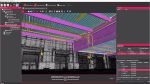
Digital measurements at Leibniz University with the faro focus3D laser scanner.
The recent refurbishment of a stunning glass roof over Guelph castle courtyard at the Leibniz University of Hanover was never going to be easy. The acclaimed institution wished to re-glaze the glasswork using aluminium profile construction with highly insulated Schco elements to improve its energy efficiency.
The listed courtyard is supported by a steel structure, with a total area of 1,200 square metres. Existing survey documents of the spatial support structure, made of steel tubing and double I beams, was old and imprecise, and did not provide all the necessary measurements.
Langenhagen-based Masche Metallbau was chosen to carry out a 3D survey, which was provided by Laser Scanning Architecture led by architect J Rechenbach. The steel substructure was measured in 12 individual scans, with the data transmitted to its in-house CAD department for planning work.
Laser Scanning Architecture was able to generate the 3D digital image of the complete geometry within two working days. The laser scanner was on site for only three hours. In comparison, manual measurement would have taken about 40-60 hours of work — without the assurance that every dimension had been determined to the last detail.
Scanning with Faro
Laser Scanning Architecture used Faro Scene software for photo-realistic display of the recorded data. The scan was read into Autodesk Navisworks, which made it possible to combine scan data with 3D data from other sources.
A comparison of target and actual values was carried out, in which the scan data was presented, superimposed on the newly created CAD plan so that deviations immediately became visible.
Planning errors were systematically avoided early on. In this case, the faulty production of a single large aluminium-glass element would have been more expensive than the entire 3D measurement of the object.
AutoCAD Architecture
Detailed drawings were made by Masche Metallbau in 2D mode using AutoCAD Architecture. The 3D point cloud model was “sliced” randomly to show the true geometry of the steel substructure at the desired position and to plan the glass elements of the roof.
The freely available Autodesk plug-in, Cloud Point Extraction, was applied directly in AutoCAD, which enabled complex 3D models to be reduced to 2D content quickly and easily. This allowed all the desired measurements to be made and the 2D details to be worked out rapidly.
Once the basic geometry had been determined and the axis spacing of the support points specified, the component library of the Schcad software was accessed to incorporate the profiles to be constructed in CAD.
Conclusion
Using 3D scanning and documentation allowed a high degree of planning reliability during the construction process. It enabled the architect and engineers to precisely portray the as-built condition in this very complex roof geometry, in an older building in which deformations may have occurred.
The successful completion of the construction project shows how accurate digital surveying data can be and the benefits 3D documentation technology offers for construction applications in surveys and architectural monument preservation.