New cloud service streams colossal laser scans to any device and supports collaborative BIM processes
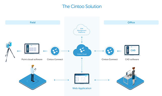
Cintoo has launched a new technology designed to handle the gigantic point clouds generated from terrestrial laser scans. Developed with a focus on BIM workflows in the AEC industries, Cintoo Cloud embeds what it describes as a unique, patent pending point cloud-to-surface and surface-to-point cloud technology that enables users to access high precision terrestrial laser scans on demand via the cloud.
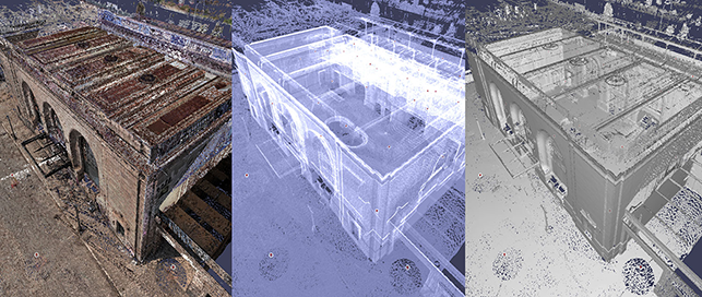
Cintoo Cloud stands out for its ability to handle even the highest scan resolution data with over a billion points. Datasets as large as 40GB can be streamed in 3D as a mesh to ‘any desktop or laptop device’ using a standard web browser. Cintoo says there is no compromise on accuracy.
“The data generated by terrestrial laser scanners is so massive that the whole industry is stuck with very desktop-centric workflows. And it’s getting worse. Modern scanners are producing higher quality data all the time, so the size of point clouds is just getting exponentially larger with every new scanner model being released in the market. This is the problem being solved with Cintoo Cloud: we are removing the bottleneck of data size that has limited the adoption of laser scanning for many years,” said Dominique Pouliquen, co-founder and CEO of Cintoo US Inc. in San Francisco.
With the point cloud-to-surface and surface-to-point cloud technology, users can convert point cloud data to 3D surfaces within Cintoo Cloud then reconvert it when required.
The solution offers a range of visualization features, with display modes in RGB, x-ray, height or 3D surface, that, according to Cintoo, reveals a granular level of scan detail not previously possible in 3D laser scanning.
Scan-to-BIM and Scan-vs-BIM workflows are supported, which Cintoo says allows laser scanning to be fully integrated in collaborative BIM processes. From a workflow perspective, the user can organize a project into work-logic areas called Work Zones (such as rooms, floors, etc.) assigning specific scans to each zone and then exporting only the necessary data for a Scan-to-BIM job. Crops of project sections and elevations can also be easily exported, while new measurements can be performed, and annotations created to inform other project users.
Cintoo Cloud is fully compatible with the Autodesk portfolio thanks to the integration of the ReCap SDK. Cintoo Cloud can read RCP files (Autodesk ReCap format for registered laser scan projects) and can generate RCS files (unified point clouds format for the Autodesk portfolio) of cropped sections or elevations, scans, Work Zones or the entire project. Cintoo Cloud is also connected to BIM 360 Docs via the Autodesk Forge platform, so that users can overlay a 3D BIM model over Reality Data in Cintoo Cloud’s viewer to check for differences. Import and export of point clouds are also available using the e57 exchange format.
Cintoo Cloud can be deployed in the cloud on either Amazon Web Services or Microsoft Azure, and customers have the option to select the specific region where the project data will be hosted. A private cloud deployment is also possible.
BBA, Canada is one of Cintoo’s North American users. Mario Laflamme, Development Manager, CAD and 3D Scan Technologies explains how Cintoo Cloud™ is changing the way he and his teams work: “Cintoo Cloud is a game changer for BBA. It allows our clients and our own teams to collaborate directly on a Reality Capture project regardless of their physical location. BBA has a dozen offices across Canada, so being able to work on the same laser scan data via the cloud saves us an enormous amount of time and resources.”
“Cintoo Cloud 1.0 is just our first step. Once the Reality Data is in the cloud, there are various analytics and measurements that can be performed. Our goal is to enrich the platform in the months to come with the web services that will help our users extract meaningful value from their laser scans: floor flatness, ADA compliance, beam deflection, cloud to cloud or cloud to BIM diff analysis, for example,” said Leonardo Hidd Fonteles, PhD, co-founder and CTO of Cintoo SAS, based in France. “Machine learning running in the cloud will also help to automatically classify the 3D data and allow our users to make the most sense of their assets. Since our Reality Data is mesh-based, we are also direct-VR and simulation ready. In the near future, we expect that remodeling from the point cloud will be less necessary since Cintoo Reality Data is already a 3D model.”
If you enjoyed this article, subscribe to AEC Magazine for FREE