New feature said to deliver higher-accuracy 3D scans and verified site data
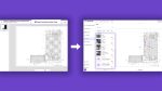
NavLive, a handheld construction scanner that combines handheld LiDAR, AI processing, and “instant” Scan‑to‑Plan output, now includes a new Control Points capability to improve the accuracy and reliability of 3D scans.
According to the company, the feature introduces a faster, integrated way for teams to ground their scans in real-world coordinates, reducing drift and alignment issues that can lead to costly errors or repeated site visits.
Control Points gives users the ability to log survey markers in real-time during a scan and to import external ground-truth coordinates into the NavLive Portal. Once captured, scans can be aligned with this real-world information through two methods: a simple rigid alignment that positions the entire model without altering the point cloud, or an optimised non-rigid alignment that adjusts the data to ensure both captured and imported coordinates match with higher precision.
Discover what’s new in technology for architecture, engineering and construction — read the latest edition of AEC Magazine
👉 Subscribe FREE here
NavLive explains that this workflow helps eliminate the subtle drift that can accumulate as operators move through large or complex environments, and allows teams to merge multiple scans into a single, coherent coordinate frame.
The feature also introduces visual verification tools that highlight alignment quality and accuracy.
“Precision is everything in construction and surveying,” said Chris Davison, CEO of NavLive. “Even small amounts of drift can undermine decisions later in a project.
“Control Points allows teams a fast and dependable way to ground every scan to real-world truth, whether they need quick alignment of a single capture or combining multiple datasets. It brings together the speed of mobile LiDAR with the accuracy of traditional survey methods, giving users data they can trust without slowing their workflow from first capture to final model.”