AEC Magazine
AEC Magazine
  • News
  • Features
  • AI
  • AI Directory
  • Workstations
  • Topic
    • AI
    • BIM
    • CAD
    • Civil engineering
    • Collaboration
    • Concept Design
    • Construction
    • Data management
    • Digital fabrication
    • Digital twins
    • Geospatial
    • MEP
    • Project management
    • Reality modelling
    • Simulation
    • Structural
    • Sustainability
    • Visualisation
    • VR/MR
  • Magazines
  • NXT BLD
  • More
    • About us
    • Authors
    • Videos
    • Sponsored content
    • Contact
    • DEVELOP3D
  • Advertise
  • Subscribe
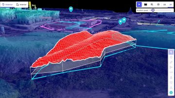
Reality modelling

Sisk boosts reality capture with DroneDeploy

Posted by AEC Magazine - November 6, 2025
Platform enhances progress tracking, design verification, and stakeholder communication.
Read More
BLK2FLY Indoor
Reality modelling

BLK2FLY gets autonomous indoor scanning

Posted by AEC Magazine - August 31, 2023
Adds capability to autonomous flying laser scanner to scan indoor spaces safely and accurately
Read More
Boston Dynamics SPOT
Reality modelling

Leica delivers autonomous scanning with robots and drones

Posted by Martyn Day - September 29, 2021
Leica launches the BLK ARC, a laser scanning module for robots, and the BLK2FLY, a fully integrated LiDAR drone
Read More
Drone mapped 3D model, courtesy of senseFly, viewed in AR using Arvizio Immerse 3D
VR/MR

AR/MR collaboration tool now supports reality models

Posted by AEC Magazine - May 6, 2021
Arvizio Immerse 3D streams drone mapped 3D models and point clouds to AR/MR devices
Read More
HCSS Aerial
Construction

Free app captures construction sites with any drone

Posted by Martyn Day - April 1, 2021
HCSS is giving away a comprehensive drone surveying app to work with its online construction data analytics platform
Read More

Stay informed

Join the AEC community

Newsletter • FREE digital magazine • print magazine

Advertisement

Latest content

  • Nemetschek Group bets big on construction

    April 14, 2026
  • Graitec earns Autodesk Gold Partner status

    April 13, 2026
  • Intel moves to build pro graphics trust

    April 9, 2026
  • Qonic drawings

    Qonic introduces native drawing generation

    April 9, 2026
  • Arcol helps SERA Architects boost collaboration

    April 8, 2026
Advertisement

© 2008 - 2026 X3DMedia
19 Leyden Street, London, E1 7LE, UK
Tel: +44(0)20 3355 7310