Point cloud specialist releases version 16.5 of its Revit- and AutoCAD-based PointSense and VirtuSurv software
Faro has introduced version 16.5 of its laser scanning software PointSense and VirtuSurv, as well as additional plug-ins for AutoCAD.
The PointSense and VirtuSurv programs provide a range of tools for processing 3D laser scan data in AutoCAD and Revit. According to Faro, the solutions complement the native Autodesk programs with additional point cloud functionality for ‘drastically accelerating’ the documentation of as-built data.
PointSense provides various industry specific solutions.
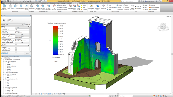
With PointSense for Revit new surface analysis tools allow users to visualise deformations from any surface in Revit. According to Faro, the results of this analysis can even be used for modelling deformed elements or complex terrains. New tools such as fitting polygons and automatically finding plane edges/rims are said to dramatically relieve the fast creation of construction aids in the project. For the first time these construction aids can be saved directly as Revit 2D and 3D families; a function that Faro says helps to fast-track Scan-to-BIM workflows.
Preservationists benefit from improved photogrammetry workflows with an enhanced image management user interface within PointSense Heritage that is designed to simplify multi-image evaluation. Users of the structure from motion software Agisoft PhotoScan can now import their calibrated photos into PointSense Heritage and use them as an additional source for processing their point cloud data.
With PointSense Building, the solution for building documentation in AutoCAD, the command for measuring ceiling tile patterns (reflected ceiling plans) has been revised completely. It now offers more options and is intuitively operable via a dialog panel.
PointSense Plant, the AutoCAD solution for industrial plant documentation, now offers a direct export for detected structural members to Autodesk Advance Steel. Results can be ported to Revit Structure as well. New “mass extraction” techniques allow for multiple fit and alignment of gridded steel sections to the point cloud with what Faro describes as substantially less time and effort.
A fully revised tie-in point routine now guides users through precise flange extraction, which Faro says avoids time consuming modelling of the point cloud. Inline-fittings such as valves can now be swapped and exchanged within existing pipe runs. Pattern recognition speeds for pipe run extraction have improved from previous releases. All PointSense solutions for AutoCAD 16.5 support the creation of horizontal slices at a defined level. PointSense Pro users benefit from a new command for simultaneously fitting multiple polygons on to point cloud sections. The creation of cross sections such as tunnels or irregular contours is drastically accelerated, says Faro. Improved construction aids plane detection is now possible just a single click. Planes automatically extend to locate their edge/rim automatically.
VirtuSurv, the software for processing point cloud data based on photo-like scan views, offers a new interface to the timber construction application SEMA.
Beyond PointSense and VirtuSurv, FARO has also released new 16.5 versions of TachyCAD and PhoToPlan.
TachyCAD, the software for real-time surveying using a total station, features laser-based projection of points. Drilling holes or patterns of ceilings and floors can now be drawn easily and even faster on-site, says Faro. TachyCAD also supports all-new total station sensors.
The photogrammetry software PhoToPlan has been equipped with an adapted image management tool and extended image imports, similar to PointSense Heritage.
The current FARO 3D Software programs process measured data from almost any device, says Faro.
If you enjoyed this article, subscribe to AEC Magazine for FREE


