SiteView integration to bring ‘simple 360° visual documentation’ to PlanRadar platform
PlanRadar is to get a new AI-powered ‘SiteView’ feature, designed to enhance the digital construction and facilities management platform’s documentation, communication and reporting capabilities.
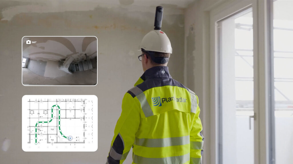
SiteView allows users to capture 360° imagery of a project while walking the site with a 360° camera attached to a helmet. Images are automatically mapped onto a 2D plan, creating a ‘detailed visual record’ of activity across every stage of the build.
With the PlanRadar integration, reality capture images are automatically transferred ready to review in PlanRadar shortly after a site walk is completed. According to PlanRadar, this makes it easy to document visual ‘as-builts’ in minutes, as well as quickly maintain any visual site documentation required. Additionally, a compare feature allows images captured on two dates to be compared side-by-side during the build to see progress and spot any deflections.
“This feature’s a game changer for PlanRadar users, combining the easy-to-use experience with the highest levels of accuracy, making it possible to achieve complete visual as-builts, field progress and photo documentation in place of taking thousands of photos,” said Ibrahim Imam, group co-CEO, PlanRadar.
“In addition, with our core documentation, communication, and ticketing platform, SiteView means anyone working on a project can now easily go back and look ‘behind the wall’ to see exactly what was built or installed, often reducing rework.”
“SiteView reduces on-site inspection time and speeds up team collaboration, allowing a complete view of the site, even when working remotely. 360° photographic images provide all the documentation needed to see what has happened, delivering complete project transparency,” added Clemens Hammerl, chief product officer, PlanRadar.
“With minimal training required, users simply set a starting position on a 2D construction plan within the PlanRadar mobile app, walk the site, and press stop when finished; our sophisticated algorithms take care of the rest.”
SiteView uses SLAM technology (Simultaneous Location and Mapping). It operates by estimating the path of the site walker on a digital construction plan, with algorithms constantly aligning sequential data to determine position and path.
The path is then aligned to the plan, using AI-powered computer vision algorithms, which integrate depth estimation and accurate localisation.