Continuing his theme of mapping, James Cutler, CEO, eMapSite, looks at the use of bespoke web portals that allow multiple levels of access (management team, project team, client, suppliers, sub-consultants, quality team) to various project resources via a simple website.
You’ve been appointed, you’ve sourced your baseline information, you’ve collected digital geographic data about the site and its environs, the site investigation team has reported back, the design team (spread across three offices) is ready to goÍ but there’s a problemÍ your existing project management tools/Intranet are not configured to allow all this data to be brought together and as project manager you now have to assimilate all the relevant information for each person involved. It’s going to be a long night! But, you guessed it, there is hope.
Never happened to you? Well, you’re either lucky and brilliant or work for one of the very few organisations that has sought, internally, to resolve this conundrum. If the former then our best wishes for continued good fortune and promotion and if the latter, for example Arup with ArupLink, then the services that are emerging to address this knowledge gap should still be of interest.
Web 2.0 / Social software / Collaborative Working
This is the year of Web 2.0 (apparently) when the implicit opportunities afforded by the “inter-web” become realisable by dint of easy-to-use, always-on, PAYU (or not at all) browser based applications that bring all of us and what we do closer together. Well that’s what some parts of the over-excitable press corps are saying! More prosaically, it is a truism that the ubiquity of web access and Internet based communications facilitate peer-to-peer (P2P – think Napster or BitTorrent) data and information exchange and thus the possibility of greater wisdom through sharing (of documents, thoughts and most anything – instant messaging, VoIP telephony, texting, email, streaming etc).
The very strength of this platform (the highly democratic P2P) is fundamentally at odds with what project managers would deem to be coherent integrated operations. Quality assurance and management systems, commercially sensitive information, conformance, compliance, security and so on are the framework on which sound business and excellent implementation depends and these can be undermined by P2P systems without very strong protocols to authenticate and control these potentially disruptive tools and technologies.
Some organisations respond to this scenario with a restrictive approach to adoption. They and many others do, though, recognise that aligning business processes with what the inter-web makes possible is both an opportunity and a business and competitive necessity. As such the challenge they face is deciding on what path to adopt that meets their needs, especially when project documentation is so diverse and is required and used in different ways by different project stakeholders, some of whom may not even be in the business.
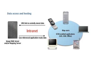
The predominant route adopted to date amongst those looking ahead has been the enhancement of corporate intranet offerings to include collaborative tools. Originally intended as internal tools, concerns arise (commercially and technically) when there is a requirement to either integrate external services or enable external access on a person, task or project related basis or both (being the most likely scenario).
Outsourcing, a dirty word?
Actually outsourcing is a concept that is entirely familiar to everyone within the AEC sector as it really is another word for sub-contracting! Outsourcing of services based on software is certainly a recent phenomenon but one that is gathering both speed and acceptance. For certain industries or roles there are collaborative tools available as web services “off the shelf”; for example, online CRM salesforce.com has been the darling of a new wave of technical stocks on the NYSE. However, such standard tools are not currently ideal in the project management and data exchange domain let alone targeted at the AEC sector.
This situation rather means that organisations seeking competitive advantage through performance enhancement and productivity tools seek out those who can both integrate seamlessly into the corporate intranet and at the same time provide a range of services and functionality that add real value or eliminate real costs. If these services are provided as part of an existing and essential toolset or service so much the better!
Service providers recognise the trade-off between paid-for “product” and the must-have functions that draw and retain their customers in the first instance. Google, Friends Reunited, AOL, various newspapers, Which? and many others provide a range of commercially successful examples of how this approach has entered mainstream online services (from the all for free to the all paid-for with plenty of “come-ons”/tempters/some now-more later to move from free/trial to paid-for models).
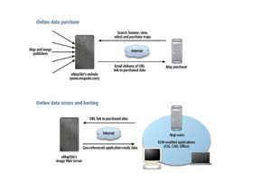
The online professional mapping arena provides more of a challenge owing to the complexity of the products and the functionality often associated with them. While the procurement interface provides benefits and operational advantages in its own right, project managers focus on “must-have” project management and information aggregation functions to help them avoid the scenario above.
e-Project Site
These tools might reasonably be grouped under an “e-Project” banner and would represent a bespoke web portal that allows multiple levels of access (management team, project team, client, suppliers, sub-consultants, quality team) to various project resources via a simple website that provides different access rights and functionality associated with the login. Functionality might include:
- Search, access, and view geographic data online
- Access associated reports
- Download PDF versions of maps/reports
- View online mapping, switching on and off data layers as required
- Administrative access to upload vector (SHP files) /raster data (ECW) and update content
- Client connection via a secure login to associated project maps/data
- Universal access to project team to all project data resources i.e. sub-contractor or equivalent
- Online data management tools according to level of access e.g. buy new data, generate quotes, edit areas, manage project data, accounts, extend licensing etc
- Data extraction via polygon tool and download
- Geocoding of PDFs to a project location
- Translation of non-SHP files to SHP on upload to enable display
- End user licence agreement interface at point of purchase in order to appropriately license data on behalf of project/client when appropriate
- Search tools (implicit or explicit) that interrogate project holdings for existing data in order to avoid duplicate purchase
- Option for multi-year licensing
- Spatial tools to display project locations, zoom in and display (raster) data (or possibly vector as well) and link to associated data (PDFs) for that project
Some of this functionality is already available on spatial web services gratis and it is anticipated that more will follow; however, as project managers and others become more au fait with what can be achieved and the benefits that can be derived it is likely that paid-for and/or custom functionality will appear. As with other markets costs reflect predicted additional server load and scalability, additional maintenance, risk etc. Modern security and user authentication tools (familiar to some from Microsoft’s MapPoint) allow centrally billed transactional and other services to be internally assigned, an essential and powerful tool for overhead allocation purposes.
Headache to solve?
eMapSite has championed this type of service for the last few years and already has in place a standard range of collaborative tools as part of the standard customer interface. In addition eMapSite is pioneering the integration of a suite of spatial tools to enrich the interrogation and retrieval of project-specific information sources.
There are a number of mechanisms available to deliver such services
- Shrink-wrapped COTS or open source solution (which may not meet all the requirements but offers a quick win for key areas; examples include MapServer (not to be confused with Autodesk’s open source offering of the same name), GeoServer, cadcorp SIS Web, MapInfo MapXtreme or ESRI ArcIMS)
- Customised COTS solution (if available)
- Internally developed solution based on COTS platform (using for example GeoConcept Information Server or ArcIMS)
- Platform independent web service based solution
Web services deliver on a customer’s specific requirements i.e. you only get (and pay for, if at all) what you need; eMapSite develops web services that are used as components in any specific service. This makes for relatively light-weight web applications that are quick to develop and easy to deploy. These can be as open or as closed as required by the customer in terms of retrieving, manipulating, displaying and outputting data.
A web service based solution can be independent of licensing fees, maintenance, staff recruitment and training, hardware investment etc and is ultimately a very flexible toolkit that can be further developed and refined in line with the changing demands and expectations of users.
The major benefit of designing something specific to your requirements is that it is exactly that. There are COTS options but these can carry risks in the form of single vendor dependency and all the ongoing costs of training, maintenance, updates etc that this incurs. You could also be committing to a significant initial outlay in investment perhaps before you have obtained corporate buy-in to the concept. The major advantage of our web services is their scalability and initial low cost of investment that allows you to build a service to meet your ongoing requirements and roll this out as corporate momentum grows and investment is made available.
This article was written by James Cutler, CEO at eMapSite, a platinum partner of Ordnance Survey and online mapping service to professional users


