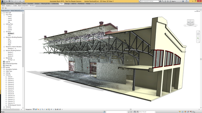
New software designed to accelerate and simplify the analysis and design of point cloud data directly in Autodesk Revit
PointSense for Revit is a brand new laser scanning software tool from FARO, designed to evaluate and convert point cloud data into BIM models inside Revit.
The software provides tools for ‘fast and precise’ creation of walls, including automatic generation of different wall types and thicknesses.
Faro says tools for fully automatic wall alignment create continuous wall ranges and orthogonal floor plans, even on varying floor levels. Wall angle tolerances can be defined freely by the user. Additional functions include automatic generation of family types based on dimensions extracted from the point cloud and the creation of digital ground models (so called Toposurface).
PointSense for Revit also provides a range of 3D design utilities. The application allows for the creation of 3D model lines and construction points via an all new 3D point snap within the point cloud. Faro says users can snap freely to point cloud points in 3D space independent from the Revit working plane. Users can also define planes from the scan data which can be used to define precise intersections lines, edges and corner points. Approximated Revit working planes can also be extracted directly from the point clouds, says Faro.
Faro also claims that users can take advantage of photo-like, planar scan views to supplement the raw Revit point cloud data. These “VirtuSurv” views are said to enable better identification of details and increase the precision of the point cloud analysis.
One specific highlight of the software is the ability to work with laser scan data directly within the family editor. New Revit elements such as windows, doors, columns, installations etc. can be generated from the scans and used within the model.
PointSense for Revit provides three different options for working with scan data in the editor. According to Faro, this makes the creation of custom family objects simple. Construction guides for families can be mapped directly from the VirtuSurv image to the editor or users can directly import point cloud sections. Finally, users can now generate and import scaled ortho images to the editor as a model reference.
Development of PointSense for Revit originally started inside surveying and as-built documentation software specialsit, Kubit, who was acquired by Faro earlier this month.
PointSense for Revit can be tested and purchased by customers on 4 May 2015.
If you enjoyed this article, subscribe to AEC Magazine for FREE
Related articles:
NEWS: Substance Plugin for 3ds Max ships
Reality Cloud Studio to ‘democratise reality capture’
NEWS: 3D Repo brings cloud expertise to smart infrastructure project
ArcGIS Maps SDK for Unreal Engine launches
Newforma expands BIM focus with BIM One acquisition
Nvidia Omniverse Enterprise collaboration platform launches
ArcGIS Basemaps integrated into Civil 3D / AutoCAD
Tridify makes BIM models ‘instantly’ viewable online
Advertisement


