New solution includes mixed reality hardhat and a new version of Trimble Connect for HoloLens, which handles larger models much better
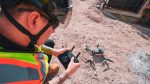
Trimble is taking orders for its Trimble XR10 with HoloLens 2 system, a site-ready mixed-reality solution that enables workers to visualize 3D data on project sites. The XR10 is more than just a HoloLens 2 integrated into an industry-standard hardhat; it also includes Trimble Connect for HoloLens, a cloud-based software optimised for the mixed reality headset.
The XR10 device includes all of the new functionality of HoloLens 2, including a flip-up-visor, wider field-of-view and more instinctive interaction enabled through hand-tracking. It can be used to overlay Constructible Building Information Models (BIM) and other digital project data onto the physical context of the site.
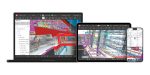
Trimble Connect for HoloLens is an application-specific extension to Trimble Connect, the cloud-based collaboration platform. New additions include step-by-step guidance for complex tasks and assigning to-do tasks and RFIs to other stakeholders.
The software currently relies on file-based transfer between the Connect platform and the various extensions (mobile, desktop, web, and HoloLens), but a spokesperson told AEC Magazine that Trimble is actively exploring data streaming options, such as Azure Remote Rendering. This should allow models with an incredibly large number of polygons to be streamed directly to the device. (We cover Azure Remote Rendering in more detail in this AEC article)
For now, Trimble is handling models of ‘any size’ in a different way. In Trimble Connect for HoloLens v3.0, which will be released on December 2, upon opening a large model in tabletop view, the app uses an ‘innovative algorithm’ to prioritise visualisation of those features on the model that are most important. The user is then provided with a section box tool where they can section the model down to certain areas of interest. Upon doing so, the app will optimise and re-render the volume inside the section box. The further narrowed down the section box is, the higher fidelity the assets in the box will be.
Once aligned on-site (1:1 scale), the application automatically prioritises rendering polygons that are most important to the user (largest, closest, within the field-of-view, etc.). As the user moves, this prioritisation “bubble” will move with them, very similar to how it’s done in video games. Users also have a new Fishbowl tool that allows them to manually set a radius of visualisation. This will section a sphere around the user past which polygons are hidden. As the user moves, as will their fishbowl. Trimble
explained that these new tools are based on the workflow expectation that users are generally only concerned with a certain area of their construction site at any given time. The company says it can prioritize that area and turn off (or lower the LoD of) other important areas so they are always seen in high fidelity.
If you enjoyed this article, subscribe to our email newsletter or print / PDF magazine for FREE