While AEC Magazine specialises in reviewing the best Building Information Modelling (BIM) systems available, we rarely get the chance to look at digital city solutions. This month Martyn Day looks at a really special UK-developed solution called CityCAD.
Computer Aided Design (CAD) has moved from drafting to design with the latest suite of BIM solutions, such as Revit, ArchiCAD and Bentley Architecture but what software is available for urban design or city planning?
A number of the products AEC Magazine has looked at in the past, such as Google SketchUp, Autodesk’s Land Explorer and 3ds Max, have tended to side more on the visualisation aspect of the equation and offer little feedback other than shadowing and aesthetics. This is more akin to drafting than design, requiring all the analytics to be performed by specialists, making most of the initial development work, at best, educated guesses until refined later on.
There is an emerging market for town planning software, despite the lack of computer-related assistance or knowledge in the majority of local government current working practices. The main contenders include CityEngine (www.procedural.com), CityScape (www.cityscapedigital.co.uk) and CityCAD (www.holisticcity.co.uk).
To me it would appear that CityCAD, from Holistic City Software, is the more interesting of these offerings due to its professional analytical and parametric nature of the software, actually assisting by providing analysis, costs and quantities throughout the planning stages. CityCAD is like BIM but for cities.
Developed in the UK by a small team of ex-town planners, CityCAD is an accurate, parametric, 3D, Windows modelling system for the early stages of the design process. The system is easy to use and incredibly quick to model with, although design can be quickly imported via DXF too. The CityCAD basic front end is a multi-level grid, which can cover miles, kilometres, 100s of metres, tens of metres and metres — enabling the creation of really large models.
On the horizon giant N, E, S, W letters provide quick orientation. The sunlight provides shadowing and the rendering quality has a pleasant cartoon-like quality, not so bad as to look like SimCity but certainly something that is engaging and can connect to all in a presentation.
City design
The user interface of CityCAD is clear and straightforward, with a menu bars, model view, properties window and a tab of dynamic analysis. The core elements are routes (roads), which can be automatically generated from straight or curved 2D lines in modelspace, or imported via 2D DXFs. These vector lines act as centre lines and automatically generate routes/roads. Areas that are enclosed with routes are automatically identified and blocks are created. All of the roads, pavements and block definitions can be user-edited or created and changed at will. These blocks could be parkland, variable density housing, offices, shops, research and development, light industrial, heavy industrial — whatever is required. With all these definitions the performance criteria, densities and floor areas are dynamically calculated.

Due to the fact that CityCAD has a parametric engine, the model displayed can also be driven depending on the requirement. For instance the density of housing can be adjusted, which automatically updates the 3D model. Using a default the system will attempt to fit the most houses on a plot given the density criteria and limits applied. So CityCAD is also useful for developers.
Pricing and free viewer
CityCAD is not available for outright purchase but costs £200 per seat per month for a six month license. The first seat actually comes with two extra seats (that is £66 per seat per month). For yearly contracts, support is given free.
The company has also just launched a free viewer for models created in CityCAD. The viewer offers many of the analysis tools but with no geometry creation capabilities, this will undoubtedly raise awareness of the design tool and will quickly share understanding of projects captured in CityCAD.
The application is a 90MB download, expanding to a 130MB application when installed. Models are saved in an Open XML format under a .URB filename and can be shared safely with interested parties.
Different block definitions can be created and simply painted on to blocks, which dynamically update with the relevant information. It is also possible for a user’s own library of frequently used urban typologies to be ‘dragged’ from a list straight into the model space.
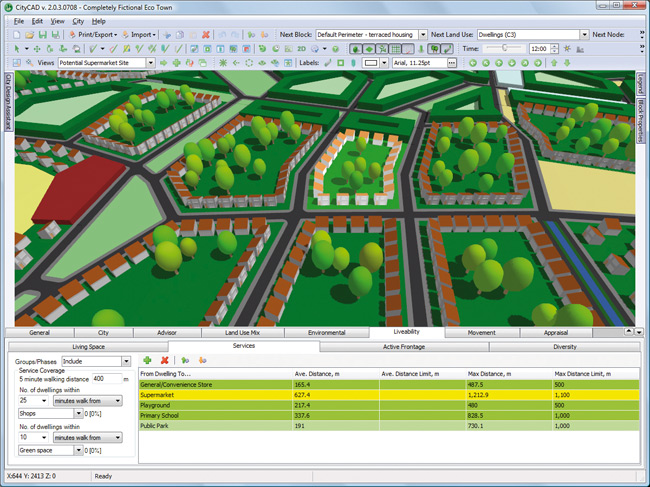
Once created, the model can be interrogated through a list of tabs and tools. This can be as simple as how far is this house from a supermarket or how far is it to the nearest school. Liveability is a big issue in urban design and CityCAD brings that clearly into view, combining a spatial model with all the latest regulation. The software even allows for phased design, showing how from start to finish these important metrics alter. Everything can be filtered by group or by phase, allowing quick manipulation of the model city.
While model creation is fast, once the design is modelled, the level of analysis provided from that work is truly fantastic. With accurate roads, housing and population density the system offers many analytical tools to understand the community needs and additional infrastructure required to comply with regulations and green initiatives such as BREAM and LEED. CO2 analysis is included in the model definitions and can be set per block or unit.
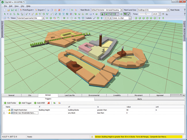
In the latest version of CityCAD, version 2, there is a new advisor panel, to provide instant feedback through the planning process. Criteria and thresholds can be set to provide warnings should important design criteria, like distance from nearest shopping, be exceeded; and road capacity issues can be identified while still modelling.
Environmental standards can be applied to individual blocks or subdivision of blocks, giving feedback on average and maximum distance to places e.g. schools, bus stops, post boxes, active frontage and diversity. This analysis will prove very useful in future green design projects and building standards that are bound to come into law.

One of the key benefits to building this city database is that as the model grows, ballpark costs can be allocated to units within the project and are immediately available. In the past urban designs have gone through complex iterative workflows with multiple disciplines to design and then assess costs and impact. With CityCAD the first design can be a better informed design, leading to fewer iterations and more accurate predictions of the cost of development.
Urban design resource
CityCAD includes a new online service, available under its ‘City Design Assistant panel’. The new urban spaces library and housing projects library means that just by selecting elements of a model, the software will go and find relevant existing designs of the same size or type.
Reference users
CityCAD has met with success both here in the UK and in the USA, with it featuring in a number of high profile projects. One of the existing customers of CityCAD is the London Borough of Tower Hamlets, which has used the software to aid its challenge of combining residential and commercial growth with a significant legacy of post-war housing development, as well as predominantly hosting the next Olympic games.
Typically the borough imports an Ordnance Survey map and then uses block drawing tools to model the surrounding area before examining the different options available for the site, using the feedback from the analytical tools.
Conclusion
CityCAD is a great application for urban design, developers, architects and anyone wanting to model and analyse large-scale projects. The inclusion of the Urban Design Reference Library allows new designs to be measured against best in class work that has been completed in the past, so not only measured against the original brief but can also against global peers.

There are some obvious omissions, such as relying on DXF when there are so many other contemporary and compact file formats. An integration with Google Maps makes sense and in discussion with Chris Sharpe, one of the founders of the company, it seems that these are already being worked on for the next release. I could see this being used by UK companies in global projects but multi-language support is not yet built-in. I understand this would take a considerable amount of work to include, so perhaps in the future.
From this base platform, CityCAD is really a brilliant application with many solid uses and well worth downloading the 30-day demo to get a feel of what it can do for you. The big task is to get the concept that CAD can benefit all town planners and developers beyond providing just pretty pictures and detailed 2D plans.
We now have the capability to capture and model geometry and information that improves our productivity and design choices. With the increasing importance of ‘engineered’ solutions to cope with lessening our impact on the environment, planning has to change and checking for conformity will increasingly rely on computer analysis in conjunction with traditional methodology.


