With all the progress being made to convert point clouds to 3D models, ‘scan to BIM’ is fast becoming a reality. One step before that would be ‘scan to drawings’ — and an Oxford-based startup sparked plenty of buzz around this at our recent NXT BLD event, writes Martyn Day
True industry disruption rarely comes from a single new technology. More often, it’s the convergence of multiple innovations that reshapes workflows and drives meaningful change. Ai is clearly one of the most influential technologies in this mix — and it’s now being woven into nearly every aspect of software and hardware development.
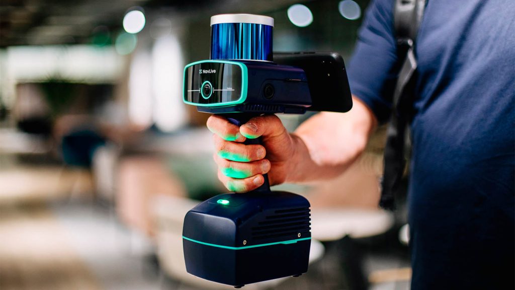
A great example of this convergence is NavLive, which combines LiDAR technology with advanced Ai processing to scan buildings and generate precise site drawings in minutes.
The company was formed in 2022 as an Oxford University spin out from the PhD research on SLAM, 3D mapping and autonomous robots, carried out by co-founder David Wisth, who is the company CTO.
The CEO and other co-founder, Chris Davison, comes from an investment background and was one of the co-founders and CEO of BigPay, a Singapore challenger bank.
Find this article plus many more in the July / August 2025 Edition of AEC Magazine
👉 Subscribe FREE here 👈

The company has raised £4 million from investment and grants, to develop a unique SLAM scanner, which captures and processes point clouds, digital images using Ai powered by Nvidia GPUs on the device. Data is then shared, via cloud, to deliver a rapid scanning solution that automatically generates 2D floor plans, 3D models, sections and elevations with a claimed accuracy of about 1cm for 1:100 RICS-grade surveys.

NavLive has a team of around 15 people and, at the moment, the handheld scanners are hand-made in the UK.
Currently, in this space you have Matterport which has a tripod-based solution at around £6k and products like Leica BLK2GO at £40,000, the Faro Orbis at £45,000 and the NavVis VLX 2 or 3 at about $30k – $60K.
At just £25,000, NavLive hits a sweet spot for rapid SLAM-style scanning, with the added benefit of delivering 2D drawings and 3D models. It comes with all the necessary software and on-board processing and the company is also working on how it could convert these models from 3D to intelligent BIM.
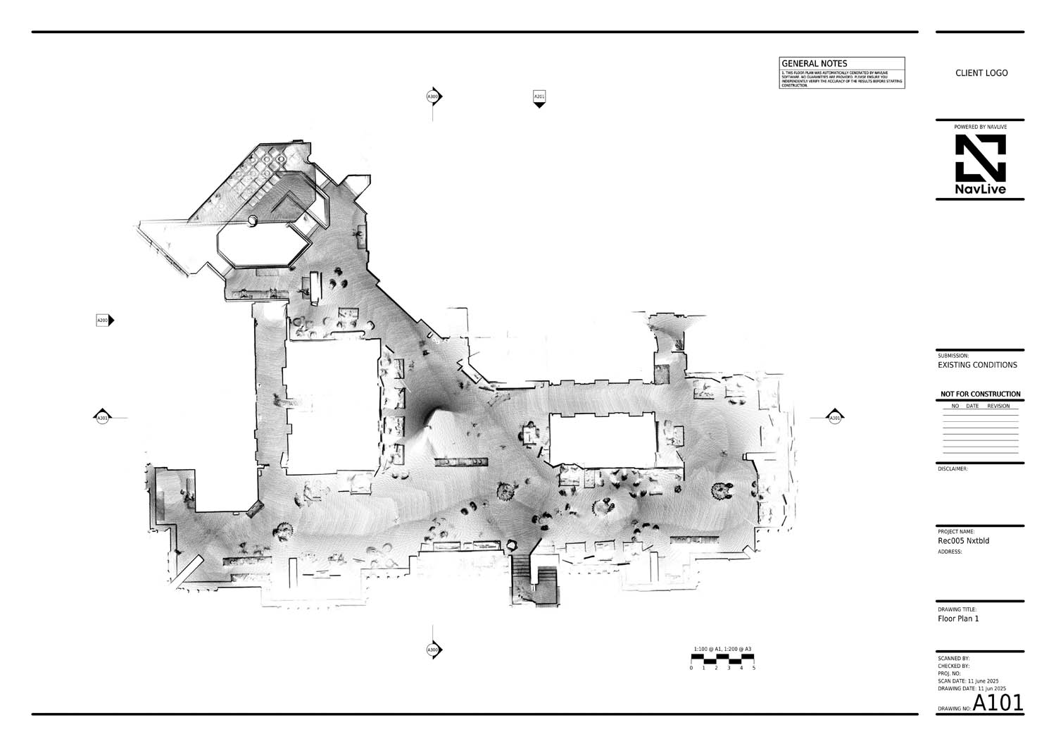
While at NXT BLD, NavLive scanned the Queen Elizabeth II building as a data set (see Figure 1) and gave demos showing how quickly it scanned spaces, simply by walking around. These were instantly turned into 2D drawings on the Samsung device built into the scanner. It was also possible to see the model and interactively create sections and elevations.
Key features
NavLive is a real time system. The input is the point cloud (SLAM is typically ‘noisy’) and the output are the 2D plans, sections and elevations. While it will capture people and other items within the scan, these can be cleaned up.
The device contains three HD image capture cameras for visual reference and documentation. NavLive will automatically work out and plot the path the user has walked, and photos can be looked at, at any point, to identify features that might not be obvious from the scan drawing.
The team claims that the NavLive device is the quickest AI-powered scan-to-BIM tool on the market, delivering ‘instant site surveys’ in one self-contained unit. The scanner is light and requires very little training to operate. It is capable of being used in multiple environments and has already been trialled in nuclear facilities.
At just £25,000, NavLive hits a sweet spot for rapid SLAM-style scanning, with the added benefit of delivering 2D drawings and 3D models
The software is mobile and desktop enabled. It automatically syncs to cloud – point clouds, drawings and models – and the results can be seen live by any other team member irrespective of geography to the actual scanning. Users can easily download files in all standard formats, including DWG, DXF, PDF for drawings, E57 or LAS for point clouds, and JPG for images. It integrates with CAD/BIM software, such as Revit, AutoCAD, and Archicad, speeding up scan-to-BIM workflows. Conclusion It’s highly unusual to find such an initially well-funded and interesting scanning device coming out of the UK; even more impressive to assemble the scanner here too. While SLAM techniques are well understood, the big benefit here is having the necessary ‘oomph’ on-board to do the processing and not just in cleaning up the point cloud but actually delivering something immediately useful – 2D drawings, plans and sections and (hopefully) ultimately BIM models.
This is an Oxford University spin out and start-up that certainly has legs.
It raises the question: could NavLive’s automatic 2D floorplan algorithms work with point clouds from any scanner?
Having covered BIMify in the May/June edition of AEC Magazine, one wonders whether you could scan a building using NavLive and then send the generated drawings to BIMify — enabling the creation of Revit BIM models using a customer’s own component libraries. That said, BIMify also tells us they support direct 3D point cloud to BIM conversion.
At NXT BLD NavLive certainly created a buzz. Unfortunately, BIMify’s CEO was unable to make the event, but that would have been a good introduction!
Rapid reality modelling is evolving fast — Robert Klashka hosted an excellent panel at NXT DEV that explored some of the latest developments.
Automation is certainly coming to nearly every granular process within traditional BIM workflows. Tasks that once took days or even weeks are being dramatically compressed by emerging technologies. The tedious, time-consuming “grunt work” is being minimised — freeing up teams to focus more on design and decision-making.
Solutions like NavLive are helping drive this shift, lowering the cost of capture while significantly reducing the time it takes to go from survey to as-built drawings — and even to as-built BIM. It’s no exaggeration to say this is the most exciting era for AEC technology innovation in the past 30 years.