What works for building the Crossrail project may not work for the development of an artist’s studio in Cornwall, but small and medium-sized projects can still benefit from BIM, writes architect Jacob Down
For architectural practices that work on projects of a predominantly small-scale nature, it’s easy to see why the adoption of BIM Level 2 may not be at the top of the agenda.
Take, for example, just a few of the key documents involved. There’s BS 1192:2007+A2:2015, PAS 1192-2:2013, PAS 1192-3:2014, BS 1192-4:2014, PAS 1192-5:2015. The list goes on, and you need to implement these alongside the Uniclass 2015 classification, the NBS BIM Tool Kit and the CIC BIM Protocol.
Despite all the industry hype surrounding BIM’s improved productivity, coordination and efficiencies, the sudden adoption of a myriad of standards, specifications and protocols could potentially be paralysing to any project without sufficient prior expertise, experience and knowledge.
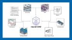
That said, there are still many benefits to be exploited through the utilisation of BIM technologies on small projects without the need to delve deeply into the realms and complexities of BIM Level 2.
Through the simple adoption of a BIM software package, in lieu of conventional 2D drafting and 3D modelling software, architects and designers can quickly tap into some of its inherent advantages and efficiencies.
Reality-captured site geometry
Over the last 18 months, there has been a fundamental shift in the tools and techniques used by surveyors to capture the spatial volumes and site features of landforms and buildings.
With the rise of reality-capture technologies like 3D lidar scanning and aerial drone photogrammetry, now common across the construction industry, aligning one’s design tools to enable full utilisation of this site-specific data makes logical sense.
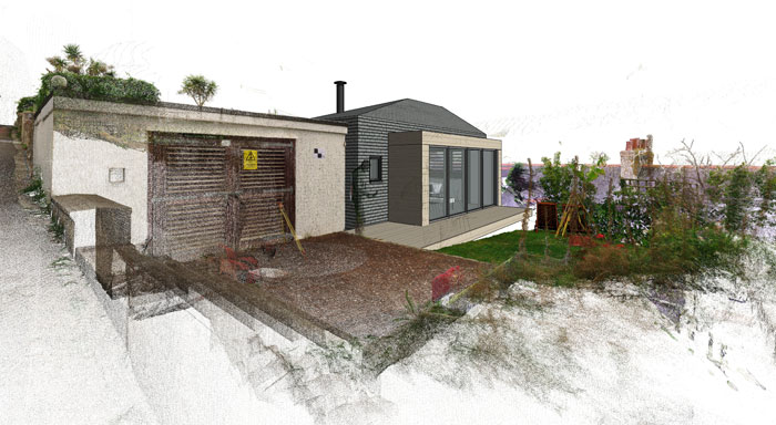
Access to such a wealth of accurate site geometry and high-definition visual content is unprecedented and utilisation of a point cloud-compatible BIM software package enables this data to be referenced and interrogated directly within the design/model space.
For the small-scale architectural project, this opens up huge design opportunities through the potential creation of highly bespoke spaces that begin to truly respond to site-specific conditions. It’s a powerful resource on projects involving alterations to existing and listed buildings, sites of a highly sensitive nature or contentious sites where party walls or rights to light maybe involved.
The ability to visualise and reference the reality-captured context within accuracies of +/– 1mm precision will provide a new level of design confidence that has yet to be fully explored within the industry.
Over the past twelve months, Poynton Bradbury Wynter Cole Architects has utilised the benefits of reality-captured site geometry on a number projects, enabling proposals to be digitally interrogated and visually represented from any viewpoint.
This not only includes external viewpoints, like a typical approach or street perspective, but also the illustration of future views through the windows of the proposal itself or existing views from neighbouring properties.
This has provided clients, planners and members of the public with a much better understanding of the proposal in question. The practice’s ability to confidently generate such information on demand to millimeter precision, meanwhile, has aided these projects to successful planning outcomes.
Design coordination
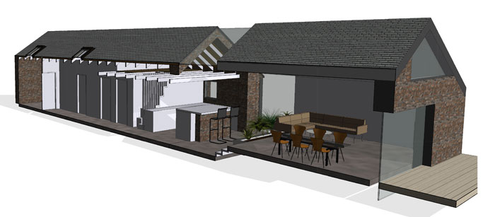
Putting aside the data rich content of the BIM model and focusing on its 3D geometry as the primary means of coordination is another way BIM technology can be utilised.
The 3D model space provides a digital environment not only to construct architectural elements but also to coordinate and interrogate the design proposals of different disciplines.
On projects of a small-scale nature, the biggest barrier seems to be the ability for the design team consultants to possess or acquire the relevant expertise and skillsets to contribute to the production of 3D information in a compatible format, with many still opting for 2D drawing outputs.
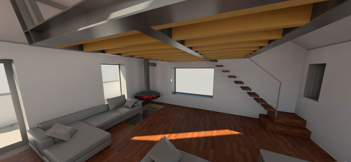
Thus, in order to successfully coordinate this information, key structural and M&E elements can be modelled into the 3D model space purely as a validation and coordination exercise.
From the architect or lead designer’s perspective, this not only facilitates the detection of any potentially clashes, but also helps inform and control aesthetic design decisions through the visual interrogation of the digital geometry and proposed materials.
Luckily, on projects of a small scale nature like the ones being discussed in this text, this should be a fairly simple undertaking – one in which the benefits of having a coordinated digital 3D model far outweigh the labour involved.
I commonly undertake that kind of exercise for the structural elements of projects, where the appointed structural engineer is not yet operating in a BIM environment. As BIM becomes more widespread among smaller-scale practices and design team consultancies, I anticipate that such exercises should in turn become obsolete.
Automation and human error
Within BIM software packages lie a whole series of automated functions that are geared towards the efficient production and coordination of construction information.
Mundane tasks such as the scheduling of doors, windows, sheets and room areas are automated. Drawing revisions are tracked and recorded within the project file, and drawings are extracted directly from the 3D model geometry. As long your 3D geometry is correct, you can be confident that the 2D geometry in the resultant plans, sections and elevations are an accurate representation of that 3D geometry.
These automated functions omit tasks that might have historically been done by human input and, in doing so, greatly reduce the margin for human error, resulting in the efficient production of higher quality and more accurate information.
Automation capacity and data management can be extended furthermore through the use of third-party plug-ins and open source visual scripting tools; dissolving the barriers of the pre-packaged BIM software and facilitating the creation of unique solutions that may become the workflows of the future.
An example is my own recent discovery of XRev UpRev, a third-party plug-in for Revit 2017. This enables the user to apply a revision to multiple sheets in a single action, something not possible natively within the software. As trivial as this sounds, it is a godsend when large lists of sheets are involved, especially with deadlines looming.
Adding value through 3D visualisation
Instrumental to BIM software is the production of a 3D model from which design information is coordinated and project data is extracted. The inherent existence of this 3D geometry facilitates the production of multiple 3D representations and visualisations – from simple perspective lines drawings, exploded axonometrics and rendered imagery, to 3D animations, stereoscopic panoramas, real-time VR and mobile BIM viewing. Such outputs are either facilitated through the software itself, or are very attainable through additional software and applications.
These more immersive forms of architectural representation have been embraced in recent years in playful, creative ways by Poynton Bradbury Wynter Cole Architects.
As far back as two Christmases ago, we used augmented reality (AR) to impose the digital BIM models of recently completed projects onto the top surface of wrapped Christmas presents. These presents were given to clients and guests, enabling them to freely rotate and move in physical space to explore scaled-down digital models of proposals, via an iPhone.
More recently, non-locomotive stereoscopic virtual reality (VR) has been implemented through coupling of iPhones and Google Cardboard-like headsets, to present proposed interiors not only for client review but also for end-user consultation and educational purposes.
The existence of this 3D geometry is likely to lead to a reduction in the outsourcing to third-party rendering service providers, as architects and designers will now have the tools in-house to create their own glossy productions and VR experiences, directly from their BIM geometry and material data.
These modes of architectural representation and communication can be highly seductive and add significant value to any project, regardless of its size. In conclusion, BIM Level 2 is a result of over two decades of government reporting, with the intention of improving cost, value and carbon performance through the use of sharable asset information on large-scale government projects such as Heathrow Terminal 5.
BIM Level 2 provides the industry with a suite of specifications, standards and protocols to best achieve this.
It’s certainly true that what works for the £14.8bn Crossrail project across central London is not necessarily going to work for a £50k artist’s studio in St. Ives, Cornwall.
That said, many benefits of BIM are scalable – downwards as well as upwards. It is through their adoption on small to medium-sized projects that the potential exists for a more organic evolution towards BIM Level 2. And that evolution should be driven from the bottom up, rather than imposed from the top down.
If you enjoyed this article, subscribe to AEC Magazine for FREE