Fibre networks form the backbone to communications in the world today. We talked to 3-GIS about the challenges of designing, constructing and managing these complex systems, while at the same time maintaining legacy networks
AEC Magazine: Compared to other utilities, what makes fibre networks more complicated to design, construct and manage – and what makes a full lifecycle approach so important?
Michael Measels: What sets apart the telecommunications networks from your conventional utility networks is that they are continually evolving. There has been a progression of terrestrial network types from copper, coax to fibre over the past several decades, which has allowed for increased bandwidth sizes but has in turn offered even more complexity in the creation and management of these networks.
Wireless technology has evolved as well, with no signs of stopping. Many of the legacy network types are still being used today and in some cases are interacting with one another. This environment is requiring GIS solutions for telecommunications to continue to evolve while still allowing customers to utilise our technologies for managing all their network assets, whether new or legacy.
In addition, the very nature of a fibre network requires a detailed understanding of every individual fibre in the fibre cable. This is exponentially different to a conventional water, electric or gas network in which the pipe or strand is the only representation of the network. For example, a fibre cable that contains 864 fibre strands must be modelled in the path vs a single pipe representation in a gas or water network. Not only do you have multiple representations in the fibre cable, the flow of data is bidirectional.
This is not the case in a conventional utility network in which the “flow” is typically modelled in a single direction. Designing and modelling this bidirectional flow requires an intrinsic knowledge of both the source and destination in terms of services and connectivity, which must be defined at the time of design in order to better understand future investment returns.
This complexity, coupled with the significant investment companies are making in fibre-based technologies, requires geospatial awareness as they manage the digital asset from beginning to end. By so doing, companies are able to take advantage of the geospatial knowledge of their assets through the entire lifecycle of their assets to include the planning, design, construction and management phase.
Tommy Siniard: I always think of the differences as a utility network has one type of energy flowing modelled in the same way. For example, a fibre network has energy flowing at different speeds in both directions. Then you have the cable network, that has the fibre network as its logical network. These layers make it extremely complex to model appropriately.
AEC: What role can design automation and Artificial Intelligence play in the design of fibre networks – now and in the future?
MM: 3-GIS has designed a significant number of route miles for both FTTH [fibre to the home] and FTTx [fibre to the x] projects using automation. Not wanting to get on my soapbox, but automated design does not mean autonomous design and I am afraid the two terms have unfortunately been used interchangeably within this context. To quote Webster, automation can be defined as follows: automatically controlled operation of an apparatus, process, or system by mechanical or electronic devices that take the place of human labour. Conversely, autonomous is defined as responding, reacting, or developing independently of the whole.
As you can see, autonomous tends to lead one down the path of being intelligent and operating without intervention, while automated is simply identifying a process or processes that can be automated in order to replace the necessity for human labour.
These processes are often those that are easily repeatable and are not necessarily influenced by outside influencers. Although the outside influencers to design can be overcome through the use of a rule-based approach, I would expect artificial intelligence will allow for the ability to overcome outside influencers and reduce the human input required to deliver an acceptable result.
As an example, automation plays a pivotal role in placing network elements down the side of the street while understanding the accumulated demand, in terms of fibre, as services are dropped off at each house. Intervention is often required to evaluate the constructability and permeability of this placement and adjustments are made to accommodate the in situ conditions. In the future I would expect artificial intelligence to play a key role in understanding why the designer chose one side of the road over the next and begin to apply this decision making to the automated output. This can, and will be, quite complex as network topology, design rules, permitting requirements, construction preferences, etc. can significantly impact the final design.
A system that can both automate the design as well as apply what it has learned from critical human decisions is the panacea when it comes to meeting the autonomous design vision.
AEC: 3-GIS is built on ArcGIS from ESRI, which has several tools for utility networks, including fibre. Why is there a need for a specialist GIS tool for fibre networks?
MM: Esri has built a tremendous platform capable of managing geospatial data across many disciplines to include utilities, and yes, even some telecommunication applications. However, the complexity of the networks deployed by telecommunication companies I spoke about earlier requires tailored applications that have the depth to both manage existing networks and their infrastructure but are also capable of evolving to meet the ever changing needs of the market. Esri is providing a time tested foundation from which to build our application and 3-GIS has been honoured to provide a premier fibre network management solution as part of a full suite offering to include Esri technology. As you once told me Tommy, “fibre is hard”. To this end, if you are not living, breathing and eating fibre networks it is very easy to get left behind. 3-GIS lives and breathes telecommunication and we have built a solid foundation from which to deploy fibre management solutions across the entire breadth of an organisation.

TS: Esri is always working to provide a platform that can support its clients and partners with the base that can be extended as needed. Our job is to build on top of that base – the extensions that meet our clients’ needs. Again, the complexity of a fibre network and its various uses make it impossible to create a single solution that is ‘Out of the Box ready’ for everyone. We work continuously to keep up with advances Esri makes in its base and then improve our solution with its advances when appropriate.
AEC: Putting bizarre coronavirus conspiracy theories to one side, 5G is massive news for the future of communications. With the 5G network supported by a fibre backbone, what role can GIS play in the roll out and what are the challenges?
TS: Planning a fibre network is greatly improved by using the data of the earth. When planning a wireless network you can easily see how information about the surrounding area can greatly improve the efficiency of the new network. With 5G, the detailed information of the surrounding area will determine where my antennas should be placed based on foliage, elevation and structures.
Millimetre bands can carry lots of data but have limitations on distance: they do not travel far (300 – 500 ft) and they are easily disrupted by anything they encounter in their path. So placement of the antennas will consider trees, structure locations and materials used in the construction of the structures.
Mm waves get obstructed easily from foliage, buildings, and that type of thing so it’s even more important to know your surroundings when planning that type of network.
AEC: ESRI has extensive capabilities to help with the efficient planning and management of 5G networks. How does 3-GIS integrate with these tools?
MM: Esri is the global GIS platform leader and provides a multitude of industryspecific applications and guidance to include telecommunications. These applications provide a strong foundation from which to create a system of engagement across organisations planning, designing, building and managing networks. 3-GIS takes advantage of this foundation by delivering a solution to address the business needs in a way that empowers users in every role in the enterprise to both understand and engage with their network assets.
As an example, our solution takes advantage of Esri’s analytic capabilities in our Prospector extension. By leveraging Esri algorithms, Prospector generates routes from source to demand point destinations which are used to derive high level costing of network expansion at scale. The ability to provision this type of Extension would be inherently difficult if it were not for the capabilities Esri provides to our solution and as such 3-GIS constantly evolves our roadmap as new technologies are made available through the Esri platform.
AEC: How do BIM data, network data and geographical data integrate?
TS: As we mentioned previously, when planning for a 5G network your surroundings determine the coverage area. Since 5G signals can be easily obstructed providing the proper placement will determine their ability to perform efficiently.
5G will also be used in office buildings and manufacturers’ sites. Understanding the footprint and configuration of these structures will allow optimum network coverage.
The BIM data is a good representation of a structure – a building – it is recorded. As mentioned previously, with 5G it is even more important to know the surroundings when placing antennas, understand what the building looks like and what material it is made out of. For example, signals bounce off glass, but can be absorbed by concrete. Big 5G markets are going after offices and multi-dwelling units. So based on that, I need to understand the layout, the overall format of the building, the footprint so I can plan my network appropriately.
BIM is also going to come into play as we get more sophisticated and start doing 3D modelling. The BIMs are going to give us the information we need to model those 3D representations correctly.
AEC: Digital twins is a very hot topic and one that we’ve covered extensively in AEC Magazine over the last 12 months. Fibre networks seem an ideal candidate to benefit for this emerging technology. Can 3-GIS harness real time network performance data and, if so, what benefits does it bring?
TS: If we can, through the use of our APIs, we could take the input of the data and associate it to the physical path that that data is flowing on. So if I were to get bit rates or information about a port, I could show how that port is serving the network and from that I would also be able to tell the end point of the network that might be seeing some reduction in bandwidth because maybe some errors being thrown off, something of that nature. So a digital twin network is a digital representation of a physical component.
What it allows me to do is to model the network on my digital, so I can make the right decisions on how I am going to use it on my physical. Or as the physical gives me information, I can model it, simulate it on the digital plan so I can see what is going on. I think we are very well suited for that because we literally build a digital twin of the physical network. I have it in my computer system when you are doing things like planning extensions for example, or I am trying to estimate what my loss is going to be over a distance, or I am trying to get a certain bandwidth to a customer. What is the best way to do that and what is going to be needed?
Short answer, yes, we are suited very well. Can we take feedback from the physical network as it is modelled? Yes.
AEC: Digital twins can benefit greatly from the amalgamation and free flow of data from many different systems. How portable is data from 3-GIS and how could it work in the context of a smart city or a national digital twin – both technically and practically?
TS: We do differently. We have an object that models the light path that is being taken and it tells the bandwidth the usage of that light path. In a larger model when it is working with others, you can tell them not only who is being served down this path – what customers are using – but what type of bandwidth I have available, the consumption (what’s being used) of what is available at any given time.

I might make it much better when I am looking to get from point A to Z to share this information with somebody so they can understand the path that needs to be taken – or as I plan it out using automation to plan the new path, being able to share that with others and let them see what is planned, so maybe they can build their plans off of that also. That would be like if I were going to run a trunk line between Atlanta and Charlotte, I’d run a big transmission cable that way and if I could share that with others, they could start doing an analysis of what they need to pull off that. They would have everything they need business-wise to take that information forward. Again, to get to revenue quicker. I don’t have to wait until it’s done to start figuring this out. I could simulate the whole thing.
AEC: With a city twin, ensuring everyone knows where the cables are in the ground is fundamental. What technologies can be used to accurately map their positions vs the old unsuccessful ways?
MM: Unfortunately I am not sure there is a magic bullet to this question. Digital cities will require a comprehensive approach across all utility disciplines to better understand the location of assets and their impact to one another in terms of geospatial coincidence, but that is probably a question for another day. If we were to focus primarily on telecommunications assets, it is important to not only understand where the cable is in the ground but to also know the elements that constitute the cable itself in terms of strands, type, placement, etc. What I mean by this is, if we were to model and simulate where and how the light is traversing this particular cable, the inherent attributes of the cable are critical.
More importantly, understanding the inherent assets of the individual strands in the cable and how they are connected is the only means by which one can accurately model the digital twin. This requires rethinking the technologies used to report the current state of the asset. Oftentimes, we see companies creating network designs using CAD-based tools which do not often allow for creating the discrete attribution of the network asset down to the strand and light path level.
Beyond this, we then see the as-built information brought back to the office from construction in the form of redlines that are quite literally drawn on a paper map! To be successful in creating a digital twin, the lifecycle of a cable should be collected in a single system capable of understanding the inherent attributes of that cable. In other words, the cable should be documented through its plan, design and build phases so that as the cable matures in terms of detail and location it can then be managed within the digital twin.
Gone are the days of simply putting the as-built drawing in a drawer for future reference. Carriers are looking for comprehensive solutions capable of modelling the lifecycle of its network assets so they can leverage the significant investments they are making in their network build outs. By doing so they can take advantage of the digital twin to inform maintenance, information sharing, reporting and more importantly new customer turnup.
TS: From our standpoint we give people the tools to accurately record the information.
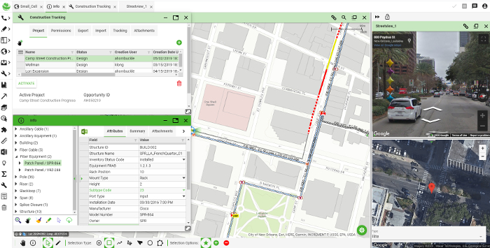
We can help them record the existing network, we can get satellite data to help very accurate information, we can record connectivity and the splices, where the cable is located in the building, take data from mobile devices with cameras to take photographs to share more information and show what’s available as far as spacing goes.
Tommy Siniard oversees the strategy and development of 3-GIS’s telecom software solutions.
Michael Measels is VP of product management. He specialises in driving vision and roadmap for 3-GIS.
If you enjoyed this article, subscribe to our email newsletter or print / PDF magazine for FREE


