Cesium for Unreal – geospatial content inside real-time engine Posted by Greg Corke - March 30, 2021 Free open-source plug-in gives users of Unreal Engine ready access to 3D geospatial content
Unreal Engine to get reality capture boost Posted by Greg Corke - March 9, 2021 Photogrammetry software developer, Capturing Reality, has joined the Epic Games family
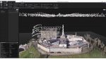
Flood risk modelling goes under the microscope Posted by AEC Magazine - March 9, 2021 Newcastle University’s high-res flood risk modelling combines LiDAR and oblique aerial photography with AI
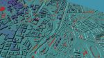
Esri UK partners with Tetra Tech on indoor mapping Posted by AEC Magazine - March 5, 2021 Service will use LiDAR scanning, data analytics and GIS to help support facilities
Vercator SLAMs the cloud: point cloud processing Posted by Martyn Day - February 1, 2021 With a growing trend to mix and match scanning technologies, Correvate recently added support for SLAM captured data to its…
Flexibility for BIM in the cloud Posted by Admin - January 28, 2021 AMD-powered cloud-based instances maximises remote productivity for leading Dutch construction firm TBI [sponsored content]
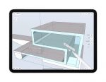
Review: Shapr3D Posted by Al Dean - September 18, 2020 A new 3D modelling application for the iPad, with impressive interactive tools for concept modelling
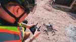
Leica BLK2GO Posted by Martyn Day - June 11, 2020 As demand for more portable, rapid scanning solutions increases, Leica has unleashed its first, handheld SLAM device and a cloud-based…
24 from the show floor Posted by Greg Corke - February 4, 2020 Greg Corke reports on 24 firms (and even more technologies) that caught his eye at the Autodesk University Expo
Leica Geosystems launches wireless BLK2GO handheld 3D scanner Posted by Admin - June 14, 2019 Spatial awareness technology allows for scanning while in motion