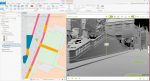
Panasonic launches $12.6k Lidar scanner Posted by Martyn Day - January 25, 2026 @mapper portable 3D scanner targets low-cost, rapid indoor mapping
SiteScape massively expands iPad / iPhone LiDAR scan area Posted by Greg Corke - May 16, 2022 AEC professionals can now combine scans to capture buildings up to 5,000 sqft.
OpenSpace 3D Scans to use iPhone/iPad LiDAR sensors Posted by AEC Magazine - November 17, 2021 Measurable three-dimensional scans can be generated within two inches of accuracy
SiteScape: LiDAR scanning on the iPhone / iPad Posted by Greg Corke - September 15, 2021 How can a commodity device like the iPhone or iPad be used to capture reality on the construction site?
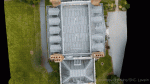
Harrow creates ‘digital twin’ with street imagery and LiDAR Posted by AEC Magazine - August 25, 2021 New approach will help London Borough improve planning, highways and Council Tax operations
SiteScape brings LiDAR scanning to the iPhone / iPad Posted by AEC Magazine - December 4, 2020 Free software can capture 9 million dimensionally-accurate points in space with a single scan, or roughly 2,000sqft
New reality capture app uses LiDAR sensor on iPad Pro Posted by Greg Corke - August 4, 2020 Sitescape software designed to lower point of entry for reality capture with point clouds in the AEC sector
LiDAR point cloud support added to Unreal Engine 4.25 Posted by AEC Magazine - May 5, 2020 Users can now import, visualise and interact with point clouds captured by laser scanners
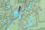
NEWS: LiDAR data at heart of Yorkshire flood alleviation model Posted by Admin - July 10, 2017 Bluesky LiDAR helps Mott MacDonald Bentley create 3D maps for Yorkshire Water
Lidar of the pack Posted by Jacob Down - July 6, 2016 The 3D lidar scan is a game-changer for architectural practices, writes Jacob Down of Poynton Bradbury Wynter Cole Architects.