High-res drone imagery allowing “faster and more cost-effective” maintenance surveys
The London Borough of Harrow has launched a new digital twin enabling remote building inspections and more immersive online experiences for members of the public.
High resolution drone imagery is allowing faster and more cost-effective maintenance surveys while 3D maps of parks are helping to increase the use of green space by residents. The council is also piloting the use of drones to help plan and support anti fly-tipping actions.
Using Site Scan drone software from Esri UK, Harrow is capturing and processing drone data to create detailed 3D models of key sites, including leisure centres, parks, arts venues and other council buildings. The new data is adding detail to Harrow’s existing low resolution digital twin where it is needed most, providing a cost-effective hybrid approach to developing a more valuable digital representation of the borough.
Discover what’s new in technology for architecture, engineering and construction — read the latest edition of AEC Magazine
👉 Subscribe FREE here
The latest imagery has been used to conduct roof surveys of Headstone Manor & Museum, a Grade 1 listed manor house dating back to 1310 and an important part of Harrow’s history. By replacing traditional scaffolding and manual inspections, the new approach saved £12,000 on this project alone.
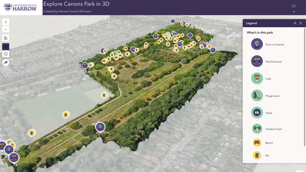
As part of the Healthier Harrow programme, interactive 360-degree imagery of the borough’s parks is being used to encourage greater use of public green space. Canons Park is one of the first examples to go live. Harrow has found that 3D interactive maps are more engaging than 2D visuals when promoting facilities such as parks, leisure centres and libraries. Healthier Harrow is an overarching health and wellbeing strategy, aiming to reduce health inequalities and promote healthier lifestyles.
Ben Jones, head of digital at London Borough of Harrow said: “The new drone approach is already saving time and money and fits our mission to work smarter and more efficiently. With minimal investment, the 3D data has the potential to deliver significant financial benefits over the next few years.”
Harrow is also piloting the use of the new drone technology to tackle fly-tipping. High resolution 3D images of potential dumping sites will enable the Environmental team to better plan preventative measures, including the positioning of signage, fencing and CCTV. By providing the 3D context of sites, more valuable insights are expected as to why certain locations suffer more from illegal dumping of waste than others.
“Using a drone and Site Scan gives us a faster and more cost-effective method of examining our buildings and other assets,” commented Sam Tizzard, head of GIS and data manager at London Borough of Harrow. “The hybrid approach using high and low resolution data keeps development costs down but delivers detail where it matters most. It’s a low cost, low risk strategy for creating a digital twin to drive significant time and cost savings. The potential for ongoing savings in roof inspections alone is huge.”
Esri’s Site Scan for ArcGIS processes unlimited drone flight data in the cloud to create 2D and 3D outputs including point clouds and high-quality 3D meshes. Distances, surface areas and volumes can be measured, supporting a wide range of planning and maintenance tasks.
This latest development builds on Harrow’s existing low-resolution aerial and street-level imagery of the whole borough. Harrow is building its digital twin using Esri’s GIS system to integrate, visualise and analyse the different data required.
Next steps include automating the integration of Revit BIM models into the digital twin and training additional staff as drone pilots to meet the growing demand for aerial data. Future plans include incorporating real-time data into the digital twin, such as traffic and weather data and testing the live monitoring of potential fly-tipping sites using drones.
“By making digital twins more affordable with drones and Site Scan, London Borough of Harrow is enabling smarter asset management, better planning and improved services for residents,” commented Paul Clarke, Head of Government at Esri UK.