Bentley has released iTwin Platform APIs for Cesium, enabling developers to integrate engineering design data with Cesium’s 3D geospatial visualisation.
Bentley Systems has released new resources to help developers use its iTwin Platform APIs within Cesium, the 3D geospatial visualisation technology that Bentley acquired in September 2024. The move is intended to streamline integration between infrastructure digital twins and large-scale geospatial applications.
The iTwin Platform provides a set of open-core APIs for creating and managing digital twins—data-rich virtual models used across the lifecycle of infrastructure assets. Cesium, now operating as part of Bentley, is known for its 3D globe and mapping technology and for originating the 3D Tiles open standard, widely adopted for streaming large-scale 3D datasets.
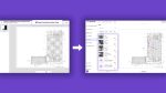
The latest release provides tutorials and example workflows that demonstrate how iTwin APIs can be used inside CesiumJS applications. Developers can, for instance, combine geospatial context streamed from Cesium ion with engineering design data managed in iTwin, and visualise both in a single environment.
Key functions highlighted in the release include:
- Data integration: Support for engineering formats from applications such as MicroStation, Revit, AutoCAD, Navisworks, and Rhino. Data is automatically converted into optimised 3D Tiles for visualisation.
- Design history: APIs allow applications to display versioned design states, enabling comparisons of alternate options.
- Metadata access: ECSQL support makes it possible to query and filter models based on attributes.
- Project workflows: Developers can incorporate tasks such as clash detection, change management, and issue tracking directly within Cesium-based applications.
Three tutorials currently available focus on adding real-world geospatial context, visualising iTwin design data in CesiumJS, and switching between design options. Bentley has said further tutorials will expand to metadata querying, navigating to individual model elements, combining multiple iTwins in a single scene, and exposing advanced iTwin APIs.
The integration reflects Bentley’s strategy following the Cesium acquisition: to bring together detailed engineering models with scalable geospatial visualisation under a single umbrella, while continuing to support open standards. For infrastructure owners, operators, and developers, the alignment is designed to reduce duplication of effort when linking project data to broader geographic settings.
The iTwin–Cesium connection is particularly relevant for organisations that need to situate detailed infrastructure data within a regional or national context, such as utilities, transportation agencies, and government bodies. It also supports use cases that involve public communication, planning, and monitoring, where both engineering detail and geographic scale are required.
By publishing these APIs and supporting resources, Bentley is signalling its intention to make its digital twin technology more accessible to developers working with open geospatial ecosystems. With Cesium now part of Bentley, the release formalises an integration that has been evolving since the company first backed the 3D Tiles standard in 2018.
Documentation and tutorials are available through Bentley’s iTwin developer portal and Cesium’s channels.