NavVis IVION transforms point clouds of buildings and assets into web-based ‘intelligent spaces’
NavVis IVION, formerly known as NavVis IndoorViewer, is a new reality capture platform designed for owners, operators and contractors.
Developed by NavVis, a specialist in indoor mobile mapping systems and reality capture technology, the platform can be used to transform point clouds of buildings and assets into web-based ‘intelligent spaces’ which are accessible to all stakeholders through a standard browser.
NavVis IVION consists of two flavours: ‘Core’ for AEC professionals and ‘Enterprise’ for factory planners and engineering departments.
NavVis IVION Core provides tools to manage 3D scans more effectively with tools for creation, collaboration, and publication.
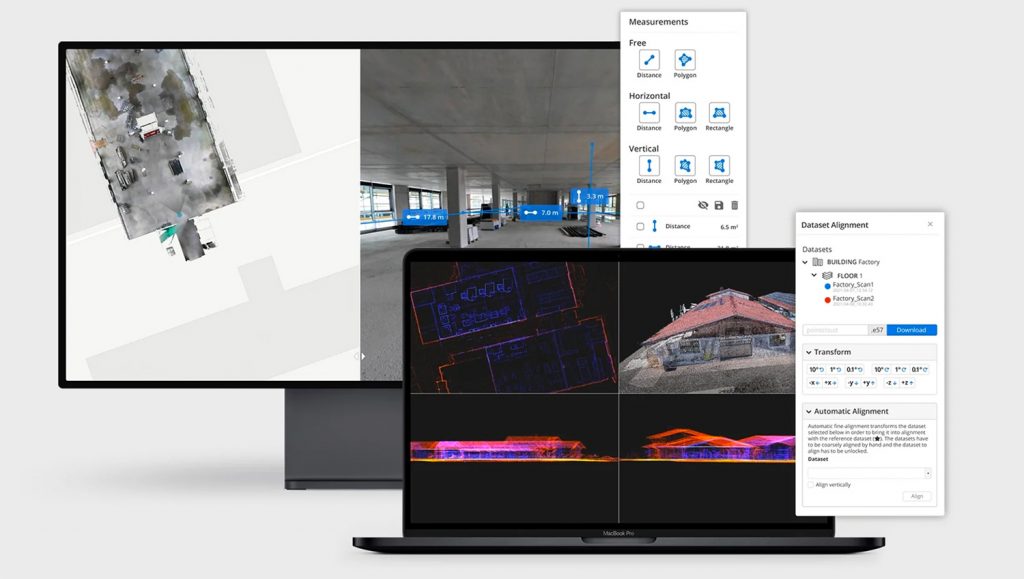
Using a standard web browser, the software designed to simplify publishing and sharing of scan data. Users can simply send a link to publish and share scans or send a deep link to specific content or a location within the scan. No downloads, plug-ins or desktop software is required.
A cloud processing add-on allows the processing of laser scan data captured by NavVis mobile mapping devices anywhere with an internet connection. According to NavVis, users can easily set up and start processing multiple datasets onsite, ready for when they’re back to the office.
Building on the existing functionality of NavVis IndoorViewer, such as point cloud downloads and virtual measurements, NavVis IVION Core offers both a ‘refreshed look’ together with new features and improvements.
These include multi-site functionality, updated user management, and site coordinate systems for ‘survey-grade’ geo-registration of data.
“The new enhancements in NavVis IVION Core simplify management of data by allowing us to utilize multiple sites in one NavVis IVION instance,” says Aaron Hunt, Lead Technical Manager at TruePoint Laser Scanning.
“We’re able to minimise software costs by maximizing the usage of an individual instance,” he continues. “The multi-site feature together with the intuitive web interface makes new project setup fast and easy. And the updated user management in NavVis IVION Core means administrators have more security control; it greatly simplifies the process of providing access.”
Daniel Aaby Holt, Landinspektør at LE34, Denmark’s largest provider of surveying and land management services, added, “The new features released with NavVis IVION Core means our customers who manage multiple sites are now able to easily access them all through one single portal that displays an overview of each site.
“We’ve also found that site coordinate system feature in NavVis IVION has enabled us to be even more precise in the geographical placement of sites and scans.
“We’re able to provide our customers with a digital representation of their space allowing the customer to view, inspect and take measurements and this has proven to be extremely valuable during the Covid-19 pandemic as access to facilities and travels has been limited.”


