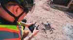
DroneDeploy partners with Cairn Homes Posted by AEC Magazine - April 1, 2026 Reality capture streamlines progress tracking, trench verification and more across Irish firm's residential portfolio
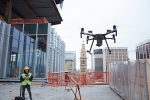
Sisk boosts reality capture with DroneDeploy Posted by AEC Magazine - November 6, 2025 Platform enhances progress tracking, design verification, and stakeholder communication.
DroneDeploy raises $15M to drive development Posted by AEC Magazine - September 9, 2025 Reality capture specialist will invest in AI and robotics products
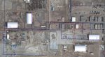
Drone surveys help cut costs on Midlands section of HS2 Posted by AEC Magazine - July 11, 2022 Balfour Beatty VINCI adopts drone software Site Scan for ArcGIS from Esri UK to digitise survey workflows
Leica delivers autonomous scanning with robots and drones Posted by Martyn Day - September 29, 2021 Leica launches the BLK ARC, a laser scanning module for robots, and the BLK2FLY, a fully integrated LiDAR drone
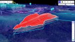
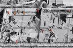
Reaching for the cloud with as-built drone data Posted by AEC Magazine - June 23, 2021 Monitoring the progress of a large data centre using reality modelling helps keep everyone on the same page and prevent…
Free app captures construction sites with any drone Posted by Martyn Day - April 1, 2021 HCSS is giving away a comprehensive drone surveying app to work with its online construction data analytics platform
Esri UK partners with Heliguy for AEC-focused drone solution Posted by AEC Magazine - October 23, 2020 Partnership designed to bring together GIS and survey teams, who have traditionally worked separately on drone-related projects
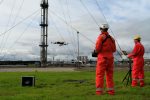
NEWS: Cyberhawk inspects gas terminal with Intel drone technology Posted by Admin - November 23, 2017 Process said to save $1 million to $5 million per day, compared to conventional methods, due to potential production loss