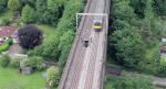
NEWS: New drone system delivers sub-5mm accurate rail surveys Posted by Admin - July 25, 2017 Plowman Craven Vogel R3D system offers ‘faster & more accurate’ way to capture rail data
NEWS: Spotscale’s global service captures buildings in 3D using drones Posted by Admin - July 10, 2017 Firm uses network of local drone operators to capture 3D models for urban planning, inspection, or design development
Drone ranger Posted by Admin - May 26, 2017 To demonstrate the potential of drone data on a live civil engineering project, 3DR enlisted the help of Autodesk to…
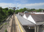
NEWS: London Underground station roof surveyed by drone Posted by Greg Corke - September 8, 2015 Lanes Group performs aerial drone survey for roof inspection project at Amersham Station
NEWS: TurboSite Drone to automate aerial reporting Posted by Greg Corke - May 11, 2015 New software uses the Dronekit SDK from 3D Robotics to add drone support to mobile site reporting tool.
10 years of NXT BLD Posted by AEC Magazine - April 25, 2026 As we approach the 10th anniversary of NXT BLD, we look back at the highlights, and industry shifts that have…
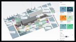
London borough cuts maintenance costs with ‘digital twin’ Posted by AEC Magazine - April 16, 2026 High-res drone imagery allowing “faster and more cost-effective” maintenance surveys
HP Construction – closing the physical / digital gap Posted by Greg Corke - March 24, 2026 HP is looking to connect 2D workflows, keeping CAD files, printed drawings and site layouts in sync
Emesent launches high accuracy SLAM scanner Posted by AEC Magazine - February 16, 2026 Emesent GX1 said to deliver "survey grade precision" with 5-10-millimetre accuracy, at mobile scanning speeds
Introducing Gaussian Splats for AEC Posted by Martyn Day - December 2, 2025 But what does this new reality capture technology mean for AEC workflows?