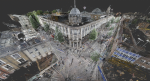
NEWS: 3D aerial laser maps provide context for BIM projects Posted by Admin - June 10, 2016 Survey company Greenhatch Group utilising detailed LiDAR models inside Autodesk Revit
From hype to Reality Posted by Randall Newton - April 4, 2016 Several hardware and software trends are converging to create incredible new design workflows
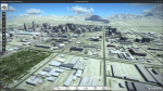
The new world of rapid site design Posted by Randall Newton - March 31, 2016 From laser scanners and drones to the cloud and ‘optioneering’ it has never been easier to capture exisiting site conditions…
NEWS: Arithmetica challenges point cloud thinking Posted by Admin - February 16, 2016 The forthcoming V2 release of Pointfuse melds point cloud and vector geometries
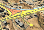
NEWS: Autodesk extends InfraWorks 360 and cuts price Posted by Admin - February 9, 2016 Dedicated roadway, bridge and drainage design modules now included free with the reduced price BIM for Infrastructure tool
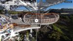
Laser scanning vs image based modelling Posted by Peter Folwell - December 9, 2015 As digital photogrammetric techniques advance at pace, the ability to use them as standalone technologies increases
Bentley merges design with reality Posted by Greg Corke - December 7, 2015 From reality capture with drones to augmented reality, Bentley Systems is embracing the real world to excite the next generation…
NEWS: Capturing Reality Forum announces call for papers Posted by Greg Corke - June 25, 2015 New three day event, held in Salzburg, Austria in November, combines best of SPAR Europe & ELMF
In pursuit of cool Posted by Greg Corke - March 11, 2015 As the surveying industry develops, a greater number of ingenious applications of the technology are making waves
Bentley opens door to reality modelling Posted by Greg Corke - March 9, 2015 Acute3D acquisition positions Bentley at the forefront of nascent market with technology that allows constant data capture, using smartphones and…