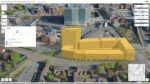
Nottingham extends visualisation for city planning Posted by AEC Magazine - September 26, 2023 Online tool to boost digital engagement within the planning process and sits alongside a public application for external stakeholders
NavVis VLX 3 wearable mobile mapper launches Posted by AEC Magazine - May 9, 2023 New lidar sensors generate twice the amount of data at range, for improved modelling accuracy and precision
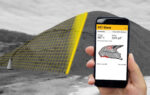
SR Measure for iPhone 14 Posted by Martyn Day - March 22, 2023 A powerful measurement tool for the iPhone uses image processing tech to measure stockpiles
Esri introduces ArcGIS Reality for reality modelling Posted by Martyn Day - February 8, 2023 Esri releases ArcGIS Reality, a reality capture extension to its flagship GIS platform
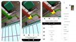
Vectorworks 2023 Posted by Martyn Day - February 1, 2023 Support for scan-to-BIM with Apple’s RoomPlan and quality checking via Solibri Inside, are among the new features
Nvidia puts spotlight on digital twin Omniverse applications Posted by AEC Magazine - September 20, 2022 AI-enabled digital twins to enhance planning and operations in railway and telco networks
Gamma AR optimises BIM model placement on site Posted by AEC Magazine - September 7, 2022 BIM models now snap to physical corners and edges of walls and columns on site automatically
Veesus launches cloud subscription for point clouds Posted by AEC Magazine - September 7, 2022 Subscription service includes cloud storage, point cloud streaming and CAD / BIM-native software
Faro acquires GeoSLAM for £22 million Posted by Greg Corke - September 2, 2022 Acquisition will give Faro a significant boost in mobile mapping
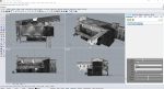
Matterport increases focus on AEC with Pro3 Camera Posted by Greg Corke - August 31, 2022 3D LiDAR scanner designed to capture indoor and outdoor spaces to ±20mm accuracy at 10m