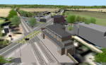
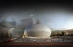
Buttress uses Bluesky 3D models for real-world context Posted by AEC Magazine - May 6, 2021 Photogrammetrically derived models provide true scale context for design proposals
NEWS: Bluesky uses smart phone footage to create 3D models Posted by Admin - February 12, 2018 Algorithms used to extract accurate measurements of essential infrastructure, such as overhead power lines
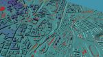
NEWS: 3DW uses Bluesky data to create interactive 3D visualisations Posted by Greg Corke - July 14, 2015 Interactive 3D models used to support planning and consultation activities for major infrastructure projects
Nottingham extends visualisation for city planning Posted by AEC Magazine - September 26, 2023 Online tool to boost digital engagement within the planning process and sits alongside a public application for external stakeholders
Mesh models underpin Bartlett dynamic map of London Posted by Martyn Day - April 13, 2021 Bluesky MetroVista Mesh Models used to produce a new Digital Twin of London
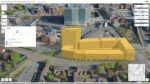
3D context models help bring architectural studies online Posted by AEC Magazine - March 16, 2021 3D models derived from aerial photography offer alternative to physical site models during lockdown
Flood risk modelling goes under the microscope Posted by AEC Magazine - March 9, 2021 Newcastle University’s high-res flood risk modelling combines LiDAR and oblique aerial photography with AI
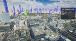
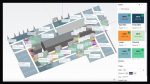
Accurate, dynamic 3D city models streamed live Posted by Admin - May 29, 2019 Dynamic 3D models to provide a visualisation and analytical platform for smart city projects, transport / infrastructure planning, development planning…
The future of AEC technology Posted by Admin - May 20, 2019 New technologies are having a profound impact on architecture, engineering & construction. At NXT BLD in London on 11 June,…
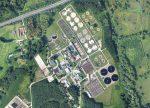
Geo models helping Anglian Water visualise infrastructure Posted by Greg Corke - November 16, 2018 Visualisations used to inform designs, communicate ideas and digitally rehearse build sequences