
Search Results for : point cloud
NEWS: Bentley releases AECOsim Building Designer CONNECT Edition
New release of multidisciplinary BIM tool benefits from the comprehensive modelling environment of Bentley CONNECT Edition

Preview: Leica BLK360
Sleek lines and ease of use mark the arrival of a new breed of 3D scanner from Leica Geosystems

NEWS: New drone system delivers sub-5mm accurate rail surveys
Plowman Craven Vogel R3D system offers ‘faster & more accurate’ way to capture rail data
NEWS: Indoor Reality integrates with ArcGIS Online
3D mobile mapping solution now allows users to ‘see’ the location of assets using cloud-based mapping platform
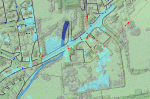
NEWS: LiDAR data at heart of Yorkshire flood alleviation model
Bluesky LiDAR helps Mott MacDonald Bentley create 3D maps for Yorkshire Water

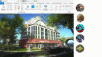
A change of heart
A big boost in productivity and a flurry of new highend project wins has seen Andrew Evans of Lime Architecture…
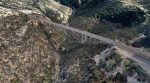
Drone ranger
To demonstrate the potential of drone data on a live civil engineering project, 3DR enlisted the help of Autodesk to…

Market forces
When the City of London Corporation needed sophisticated surveying performed at the Poultry Market at Smithfield, Plowman Craven had the…
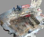
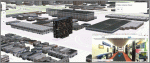
First-class capture
The Costain Group has used ContextCapture from Bentley Systems to document site conditions for massive renovations at London Bridge Station


