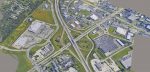
Future reality – from streamable, scalable meshes to deep learning Posted by Greg Corke - November 30, 2017 The latest developments in reality modelling at Bentley Systems, including streamable, scalable reality meshes and automatic mesh classification using deep…
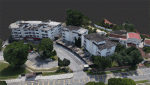
Large as life Posted by Admin - November 29, 2017 How HaleTIP used ClearEdge3D software to create an as-built model of a complex industrial building in just a few weeks
LumenRT: scalable viz for everyone Posted by Greg Corke - November 27, 2017 By harnessing the power of the cloud together with engineering accurate scalable meshes, Bentley is looking to make model complexity…
NEWS: ReviCAD brands to RSE Technologies Posted by Admin - November 24, 2017 Company takes on new staff to help support expanded range of digital design services
NEWS: GEOSLAM enhances SLAM registration software Posted by Admin - November 24, 2017 Company also launches new generation hand-held, lightweight mobile laser scanner
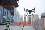
NEWS: 3DR integrates Site Scan with Autodesk BIM 360 Posted by Admin - November 12, 2017 Integration of 3DR’s drone data platform and Autodesk’s project management tool designed to improve collaboration and quality control
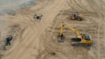
Eye in the sky Posted by Admin - September 27, 2017 At Isachsen, drones have become one of the most cost-effective tools for surveying projects in fast and non-intrusive ways. Today,…
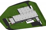
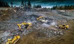
Vertical lift Posted by Admin - September 25, 2017 Argyle Asia puts to the test a new ‘perimeter scan’ flight mode in the 3DR commercial drone platform, in order…
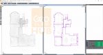
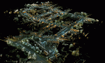
Mapping Newark Posted by Admin - September 25, 2017 A mobile mapping device from Topcon has allowed companies working on a sewerage upgrade in Newark, Nottinghamshire to better understand…