Varjo Teleport VR launches for collaborative design/review Posted by Greg Corke - November 19, 2021 Software is the first step towards a ‘photorealistic metaverse’ as part of the Varjo Reality Cloud platform
Digital twins: the case for open-source Posted by Keith Bentley - October 1, 2021 In order to achieve sustainable infrastructure digital twins, it is imperative that you build your systems around open-source technology
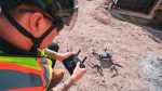
Leica delivers autonomous scanning with robots and drones Posted by Martyn Day - September 29, 2021 Leica launches the BLK ARC, a laser scanning module for robots, and the BLK2FLY, a fully integrated LiDAR drone
12 tools for collaborative VR for architecture Posted by Greg Corke - July 27, 2021 Our top picks for tools that allow AEC teams to collaborate effectively in the virtual world
Why are we still waiting for Augmented Reality? Posted by Martyn Day - July 21, 2021 As VR continues its rise, AR seems to have got lost on the way to the party. We search for…
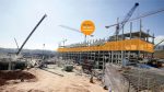
GeoSLAM technology monitors construction progress Posted by AEC Magazine - July 7, 2021 SLAM solution uses automated analytics to compare point clouds to CAD
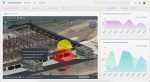
Varjo introduces ‘virtual teleportation’ platform Posted by Greg Corke - June 24, 2021 Varjo Reality Cloud will allow collaborators to ‘teleport’ to a construction site in real-time
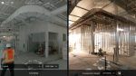
Cupix launches CupixWorks 2.0 Posted by AEC Magazine - June 15, 2021 3D ‘digital twin’ platform designed to add value across project lifecycle
AR/MR collaboration tool now supports reality models Posted by AEC Magazine - May 6, 2021 Arvizio Immerse 3D streams drone mapped 3D models and point clouds to AR/MR devices
Mesh models underpin Bartlett dynamic map of London Posted by Martyn Day - April 13, 2021 Bluesky MetroVista Mesh Models used to produce a new Digital Twin of London