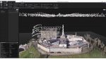
Mesh models underpin Bartlett dynamic map of London Posted by Martyn Day - April 13, 2021 Bluesky MetroVista Mesh Models used to produce a new Digital Twin of London
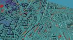
Cesium for Unreal – geospatial content inside real-time engine Posted by Greg Corke - March 30, 2021 Free open-source plug-in gives users of Unreal Engine ready access to 3D geospatial content
Unreal Engine to get reality capture boost Posted by Greg Corke - March 9, 2021 Photogrammetry software developer, Capturing Reality, has joined the Epic Games family
Flood risk modelling goes under the microscope Posted by AEC Magazine - March 9, 2021 Newcastle University’s high-res flood risk modelling combines LiDAR and oblique aerial photography with AI
Esri UK partners with Tetra Tech on indoor mapping Posted by AEC Magazine - March 5, 2021 Service will use LiDAR scanning, data analytics and GIS to help support facilities
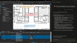
Vercator SLAMs the cloud: point cloud processing Posted by Martyn Day - February 1, 2021 With a growing trend to mix and match scanning technologies, Correvate recently added support for SLAM captured data to its…
Flexibility for BIM in the cloud Posted by Admin - January 28, 2021 AMD-powered cloud-based instances maximises remote productivity for leading Dutch construction firm TBI [sponsored content]
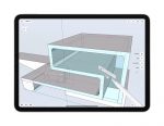
Review: Shapr3D Posted by Al Dean - September 18, 2020 A new 3D modelling application for the iPad, with impressive interactive tools for concept modelling
Leica BLK2GO Posted by Martyn Day - June 11, 2020 As demand for more portable, rapid scanning solutions increases, Leica has unleashed its first, handheld SLAM device and a cloud-based…
24 from the show floor Posted by Greg Corke - February 4, 2020 Greg Corke reports on 24 firms (and even more technologies) that caught his eye at the Autodesk University Expo