Leica Geosystems launches wireless BLK2GO handheld 3D scanner Posted by Admin - June 14, 2019 Spatial awareness technology allows for scanning while in motion
Accurate, dynamic 3D city models streamed live Posted by Admin - May 29, 2019 Dynamic 3D models to provide a visualisation and analytical platform for smart city projects, transport / infrastructure planning, development planning…
Welcome to the future Posted by Randall Newton - February 20, 2019 To celebrate the 100th edition of AEC Magazine, we explore what construction might look like in 2036 when the 200th…
New VR tool focuses on collaborative design review Posted by Admin - January 7, 2019 Symmetry from DVERSE works with SketchUp, with support for IFC and Revit files to follow later
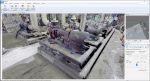
Elysium InfiPoints Posted by Al Dean - July 13, 2018 Having mastered the world of CAD data translation, Elysium has turned its attention to the processing of large-scale, complex point…
Aladdin’s CAVE Posted by Greg Corke - June 28, 2018 Bentley Systems and Fulcro recently installed a BIM CAVE at the Institution of Civil Engineers in London to help educate…
NEWS: NavVis enhances indoor mapping precision Posted by Admin - February 16, 2018 Precision SLAM technology said to ‘significantly reduce’ drift error and improve SLAM accuracy
NEWS: Doxel uses reality capture and AI to boost construction productivity Posted by Greg Corke - January 24, 2018 Autonomous drones and robots capture site conditions, then deep learning algorithms recognise objects in real time.