Right on track Posted by Admin - January 24, 2018 Tom Wren of Plowman Craven discusses the company’s use of drone technology in surveying railway track and infrastructure
BIM in the dock Posted by May Winfield - January 24, 2018 If left untackled, inconsistencies in the ways that BIM is defined in legal contracts could pave the way to disputes,…
Sponsored: Scan-to-BIM with ReCap and Revit: An Alpine Case Study Posted by Admin - December 14, 2017 French firm ATFF uses Autodesk ReCap and Autodesk Revit to provide scan-to-BIM services for a hospital renovation in the Alps
Bridging the gap: engineering & construction Posted by Greg Corke - November 30, 2017 The maturing partnership between Bentley and Topcon that aims to streamline engineering and construction through a connected data environment in…
Future reality – from streamable, scalable meshes to deep learning Posted by Greg Corke - November 30, 2017 The latest developments in reality modelling at Bentley Systems, including streamable, scalable reality meshes and automatic mesh classification using deep…
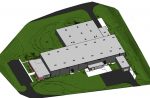
Large as life Posted by Admin - November 29, 2017 How HaleTIP used ClearEdge3D software to create an as-built model of a complex industrial building in just a few weeks
The future of smart cities Posted by Admin - November 22, 2017 How can architects, engineers & construction professionals help to build smart cities that put the needs of citizens front and…
NEWS: 3DR integrates Site Scan with Autodesk BIM 360 Posted by Admin - November 12, 2017 Integration of 3DR’s drone data platform and Autodesk’s project management tool designed to improve collaboration and quality control
Eye in the sky Posted by Admin - September 27, 2017 At Isachsen, drones have become one of the most cost-effective tools for surveying projects in fast and non-intrusive ways. Today,…
Vertical lift Posted by Admin - September 25, 2017 Argyle Asia puts to the test a new ‘perimeter scan’ flight mode in the 3DR commercial drone platform, in order…